Garry
Horizon VFR Photo Scenery for FSX
Moderators: Guru's, The Ministry
-
Garry Russell
- The Ministry
- Posts: 27180
- Joined: 29 Jan 2005, 00:53
- Location: On the other side of the wall
Re: Horizon VFR Photo Scenery for FSX
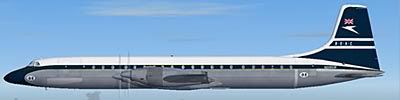
The SAS had a Trident somewhere....perhaps they've upgraded it 
Garry
Garry
Garry
"In the world of virtual reality things are not always what they seem."
"In the world of virtual reality things are not always what they seem."

Re: Horizon VFR Photo Scenery for FSX
I lived in Hereford for 20 years but do'nt recognize that area, Used to leave my car in one of the many wartime buildings in that camp while I was in Northern Ireland.
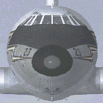
A google search came back with this for Pontrilais that airframe looks like a mockup, the latitude longitude is for said airframe.
What area was that screeny taken from ?
SAS Pontrilais Herefordshire
Lat 51°58'24.92"N Lon 2°51'59.89"W
A google search came back with this for Pontrilais that airframe looks like a mockup, the latitude longitude is for said airframe.
What area was that screeny taken from ?
SAS Pontrilais Herefordshire
Lat 51°58'24.92"N Lon 2°51'59.89"W
Rich

Re: Horizon VFR Photo Scenery for FSX
Hi guys, it's NOT Herefordshire... I have only installed Vol I at the moment ( Southern England & South Wales) there's an airport in the distance...
Cheers,
Jan
Cheers,
Jan
Re: Horizon VFR Photo Scenery for FSX
Apart from Shobdon there are no airports in Herefordshire, Staverton, Gloucestershire I think is the nearest, that is just off vol1
Rich
Re: Horizon VFR Photo Scenery for FSX
Hi Ben, really ??..... I just checked Luton, bit lower than Hereford and it is not part of the Vol I scenery.... ( i have the Horizon version ) the threshold of the Vol 1 photoreal scenery is very close by though. As the scenery is mapped in a straight line and Luton is lower than Hereford...XR219 wrote:Hi Javis... Hereford is in Vol 1. ;-)
Any airfield in the neighbourhood of Hereford ?
But, in any case, the screenie was taken on my first trip over this new amazing photoreal scenery, from Heathrow on a south-easterly course to see if there are blue skies over the white cliffs of Dover. I haven't hummed that song for a long time whilst flying my Spit, no fun if you can't put the picture to it, is it. Seems like i can give a try again although i think the white looks a little rusty...
There'll be blue skies over
the rusty white cliffs of Dover.... mmmm.. that doesn't rhyme too well
White cliffs look nice between Seaford and Lydd.
Cheers,
Jan
Re: Horizon VFR Photo Scenery for FSX
South East from Heathrow is in the opposite direction to Hereford.
There is only 1 GA airfield in Herefordshire that Is Shobdon. The nearest I think is Staverton in Gloucestershire then Cardiff and the Birmingham bunch.
There is only 1 GA airfield in Herefordshire that Is Shobdon. The nearest I think is Staverton in Gloucestershire then Cardiff and the Birmingham bunch.
Rich
Re: Horizon VFR Photo Scenery for FSX
Just been looking at that screeny again, since there are no roads anywhere near that plane how did it get there ? there seems no obvious purpose for it there, did it force land there ? no evidence of ground scrape or tree damage anyone got firm ideas of what it is.
A mystery ?
A mystery ?
Rich
-
DaveG

- The Gurus
- Posts: 8091
- Joined: 23 Jun 2004, 18:05
- Location: in a deep, dark hole somewhere.
- Contact:
Re: Horizon VFR Photo Scenery for FSX
Isn't this just a case of a flying aircraft being photographed when making the aerial maps, an not being edited out?
Dave G.
Re: Horizon VFR Photo Scenery for FSX
STUPID Sorry chaps... I was looking at the old FS9 scenery box... Javis your absolutely right. ;-)
Ben.