
Brian
Amazing Photo Sceneries!!!
Moderators: Guru's, The Ministry
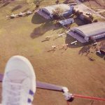
I don't have the exact spec in front of me, but the normal scenery resolution is something like 4.7m/pixel where as these sceneries are something like 1.2m/pixel.
On his site you will see references to High Res & Low Res. The Low Res scenery is at the default resolution, & therefore High Res is...
Its a pity its America (sorry to Americans) but yes would'nt it be great to fly over Exmoor, or the Yorkshire Dales with scenery as crisp as this - and this is free.
Bob
Last edited by delticbob on 01 Dec 2006, 22:32, edited 1 time in total.
I can fly now with my fantastic new PC

I presume that it all depends on the sources, rather than the publisher.tonymadge wrote:Amazing stuff...why couldn't VFR UK do something like this instead of the shyte they sold ???

A birdy tells me that it's possible to work with 15cm textures in FSX.. the same birdy also says that it's impressive to see..
Dan.

-
DaveB

- The Ministry
- Posts: 30457
- Joined: 17 Jun 2004, 20:46
- Location: Pelsall, West Mids, UK
- Contact:
It's also true to say that UKVFR is older than God's dog (being released originally for FS2002) and a handful of years down the line, this is how things have progressed. Gotta agree with delticbob though.. the Yorkshire Dales might get me interested.. not more American scenery I never use

ATB
DaveB :tab:


Old sailors never die.. they just smell that way!
-
tonymadge
- Vintage Pair

- Posts: 2082
- Joined: 28 Jun 2004, 14:49
- Location: middle earth next to the public toilet
- Contact:
Dave at the same time VFR was peddling their stuff the Yanks were producing far better VFR scenery and with night textures!! Still I am waiting for the updated VFR scenery where all the roads are removed...cause soon we won't be able to afford to use them..Ooh er political stuff now 
AMD Phenom II X4 BE 965 @ 3.80GHz
nVidia GTX 560 TI 448 Cores
-
RAF_Quantum

- The Gurus
- Posts: 2745
- Joined: 04 Jul 2004, 23:36
- Location: NE Lincolnshire UK
- Contact:
Hi Tony,
Rumour has it that the deletion of roads upgrade you describe has been scrubbed. The latest news on the grapevine is that the modellers are busy making different models of toll booths at various locations throughout the UK. Due to the data that will be needed this will be a DVD release only.
Rumour has it that the deletion of roads upgrade you describe has been scrubbed. The latest news on the grapevine is that the modellers are busy making different models of toll booths at various locations throughout the UK. Due to the data that will be needed this will be a DVD release only.

-
Garry Russell
- The Ministry
- Posts: 27180
- Joined: 29 Jan 2005, 00:53
- Location: On the other side of the wall


There is a new version of VFR scenery coming out, which might be worth getting FSX for, guys......
http://www.justflight.com/vfr-info.asp
http://www.justflight.com/vfr-info.asp