Aden cam Beverley reworked

The place to request or publish repaints for Classic British Aircraft. Please note... no FICTIONAL livery requests!

Moderators: Guru's, The Ministry, The Painters

User avatar
Rich
VC10
VC10
Posts: 538
Joined: 26 Jun 2004, 23:12
Location: Philippines

Post by Rich »

Ian many thanks for your effort, as you say my AFCAD is probably very close to correct unfortunatly even with the wonders of google earth no visible evidence of the strip remain.

What with the ravages of time, erosion, new building,cultivation and a failing memory no sign remains, even if I went back I doubt if I would recognize any of it with so much progress there.

I think we can call it a day and I will keep my AFCAD as it is since it is my memory of it.

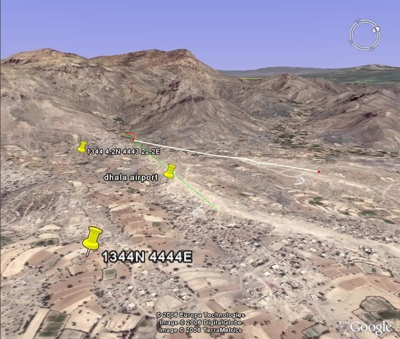
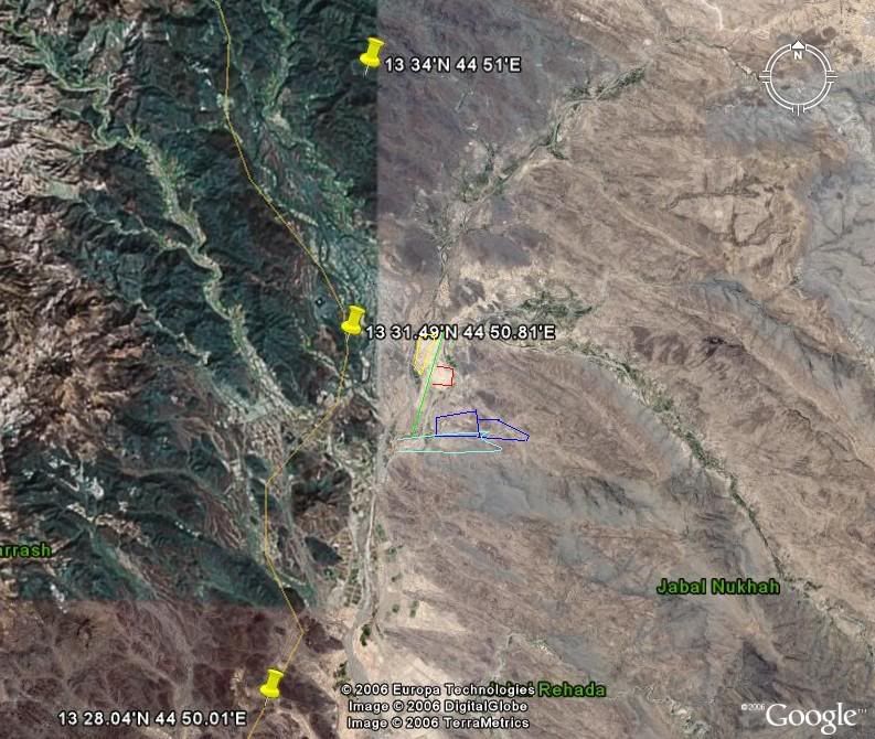
Seq10 I think is the nearest I think but the green line I added the red semi circle the turn around.

Image

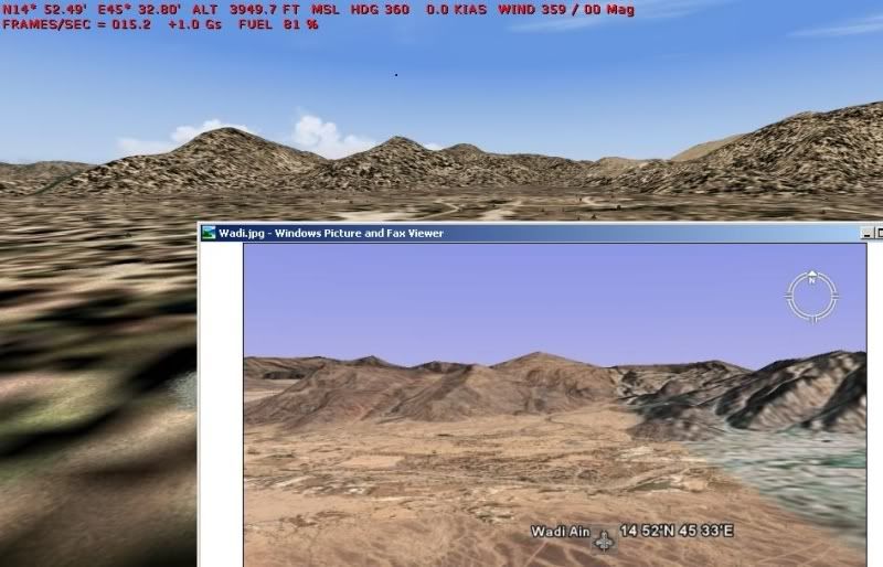
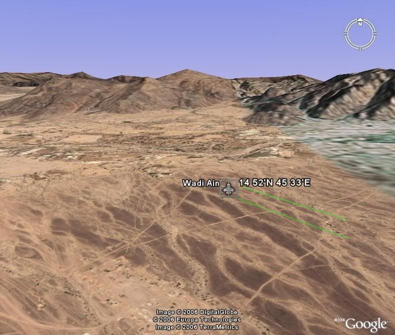
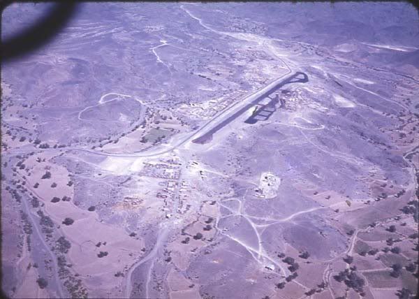
This is a set of Pics I found today this Bev has just landed as you can see by the distance to the mountains in the background and I think full flap setting, in the colour pic you can see a horizontal white line around the middle of the pic, I do beleive that is the turn around end of the runway

http://www.onceamarinealwaysamarine.co. ... nsend5.htm

Peter I do'nt think you would be happy to put a Venom or Hunter down there with that low quality talcum powder surface.

The problem with the info I originaly found on Dhala, Wadi Ain and Beihan was although they had altitude, runway length and one set of co ords I could 'nt be sure of the position of the runway, was the position in the middle of the runway or 1 of the ends and worst of all no heading.

Unfortunatly no info at all on Habilain I spent hours trundling up and down the Dhala road in the Stalwart (drove one for 18 months, I do believe the nicest cabby anytime) looking for likely spots hoping the Ms road is the same as the map I found.

Hope this has'nt bored anyone, Flight simming has many facets some of little interest to the majority, many thanks for your patience
Rich

User avatar
petermcleland
Red Arrows
Red Arrows
Posts: 5201
Joined: 25 Jul 2004, 10:28
Location: Dartmouth, Devon
Contact:

Post by petermcleland »

Thanks for all the fascinating shots...I've just been rummaging through a trunk where I keep my remaining flight maps, hoping to find something to scan...Sadly, nothing remains of this area. The nearest maps I have are over the other side of Arabia...Sharjah, Buraimi and Jebal Achkdar etc.

How sad that I didn't keep more charts. They do bring back a lot of memories.

ianhind
Concorde
Concorde
Posts: 1935
Joined: 01 Aug 2005, 10:55
Location: Nottinghamshire

Post by ianhind »

Rich,

Haven't given up on you!


Airport Code: WDA
Airport name: Wadi Ain
Runway Length: 3904 ft.
Runway Elevation: 3940 ft.
Longitude: 45° 33' 0" E
Latitude: 14° 52' 0" N

The view of this area is in http://www.btinternet.com/~calypsomedia ... d/Wadi.jpg

Interestingly Google puts the "airport" in the same position.


For Al_Habilayn, I found this reference: http://www.fallingrain.com/world/YM/0/Al_Habilayn.html

And this location and your two potential sites are shown in
http://www.btinternet.com/~calypsomedia ... /AlAb1.jpg

Two of these sites are outside the detailed Google Earth locations - just one allows a detailed view - shown in http://www.btinternet.com/~calypsomedia ... /AlAb2.jpg

Once again, down to your decision.

Finally the roads in Google Earth shown as a yellow line don't match exactly with real life in this part of the world, and I suspect that FS2004 used the same source.

So endeth this tour of somewhere I barely knew existed, except as referred to as "Aden".

Ian

Ian

User avatar
Rich
VC10
VC10
Posts: 538
Joined: 26 Jun 2004, 23:12
Location: Philippines

Post by Rich »

Ian.

thanks for the Habilayn and Wadi Ain pics, my western end of the runway in the AFCAD I did for it is almost spot on with your little plane in a box and is more or less on the same heading as the straight bit running to the east from it green lines, 270 deg but maybe it needs tilting a bit more north 274 or 275 ?, so by pure chance my AFCAD may be in the right place but by no means certain.

We never went to Wadi Ain and I do'nt think it was occupied while we were there.

Image

Image

Heading 360 from the given co ords even though the mesh may not be 100% accurate there are similarities I think.

There is another Beihan that I think is in stil in use with a alsphalt runway about 10 miles SSE of Wadi Ain, opperated by the government there,I have enough info on that but you may want to look at it this I think was also a forward airstrip.

BEIHAN

Latitude N14° 46' 55.10
Longitude E045° 43' 12.30
Elevation 3800 feet

Runway 17
Surface ASPHALT
True Heading 173.0
Latitude N14° 47' 22.08
Longitude E045° 43' 08.89
Landing Distance 5480 feet
Takeoff Distance 5480 feet


Runway 35
Surface ASPHALT
True Heading 353.0
Latitude N14° 46' 28.12
Longitude E045° 43' 15.70
Landing Distance 5480 feet
Takeoff Distance 5480 feet


Habilain I do believe if my green line is long enough is the marked area to the east of your pin N13* 31.49',E44* 50.81', there certainly does'nt seem to be anywhere else suitable.

looking at these 2 air photos and your google there are a lot of similarities in the terain so If I am right the yellow box was the site of our holiday resort, the red, the site of the RAF and Army Air Corps admin and aircraft parking, the blue box encloses a village which appears to be still there, the light blue marks a small wadi that if right we went over to see our recovery mechs recovering a Arab's truck which had fell into the wadi. as you say

the route of your yellow line marking the road does look odd.

Image

Given to me by Peter Pickering Aden Airways Forum

Image
on my mate Wobbly's site

Image


Sorry for the delay answering, my video card died on me, now running on a temp replacement.

I have been looking around Dhala again and with what we now know, think I have a suitable couple of hills to put the 2 camps on.

Ian MANY THANKS for all your work in finaly for me at least pinning down the lost bits of history. Very nostalgic for me Thanks again

It was certainly A sight to behold when the Bev touched down at Dhala and applied reverse then dissapeared in a cloud of dust, saw a pic of one landing in Habilain before the oil treatment in which it looked as if he had slowed enough to come out of reverse on the 2 inners if they could (one for Kevin) as the nose was clear but the dust in front of the outers suggest they were still in reverse
Rich

Post Reply