
Ian, this is the info as downloaded looks like I moved it slightly to appear better against the mesh which is not by the way the default Fs mesh Fs looks more like Salisbury Plain.
Airport Code: DHL
Airport name: Dhala
Runway Length: 4000 ft.
Runway Elevation: 4750 ft.
City: Dhala
Country: Yemen
Country Abbrev.: YE
World Area Code: 694
GMT Offset: -3.0
Longitude: 44° 43' 45" E
Latitude: 13° 44' 15" N
The last figures in Lat and Lon dffer from the Afcad.
Garry having spent a good few hours on that strip I know it is taking off the flaps as you say are a give away, it would be a pretty steep descent to touch down there.
Kit I had 3 flights in Bev's Singapore to Kuching, Borneo and 6 months later back to Singapore, Kuching was my first and only experience of being in a aircraft reversing on the ground under it's own steam whe it reversed into it's parking spot. The third Bev flight was in Aden from Habilain to that very airstrip Dhala, slammed into reverse as soon as the wheels were on the deck, they were not carrying full loads there in those conditions, hot and fairly high, you cans see the dust pouring over the gear with some behind when in reverse you could hardly see them.
I was Army not RAF.
Aden cam Beverley reworked
Moderators: Guru's, The Ministry, The Painters
Link to another set of pics including 2 of Dhala with a good view of the overrun stopper and 1 of XM106 in action doing a container drop
http://www.air-despatch.co.uk/album/ron-n/ron-n.htm
http://www.air-despatch.co.uk/album/ron-n/ron-n.htm
Rich
Rich
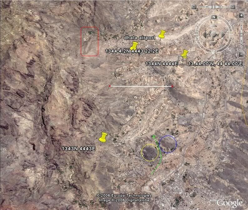
I've been doing a bit of looking about Dhala.
Your latest location is about the same as "Dhala Airport" that I found.
Anyway here is another Google Earth from a bit further away, with a 4500 foot line drawn for scale. The other "possible" locations are shown as pins - probably allthe same really, just with the lat/long rounded.
And yes which mesh are you using?
Edit: picture removed - same one in Rich's response
Last edited by ianhind on 10 Nov 2006, 11:26, edited 1 time in total.
Hi Ian thanks for the Google,I did a bit of doodling on it the red box looks the part but
but the heading does'nt look right.
If I am right the blue circle is where our camp was and the yellow circle the FRA camp,
neither of these little hills were much over 50ft above the local ground level with a small
valley between, the RAF used to lay on a display of low flying most evenings consisting of a
single Hunter F6 I think, flying through that valley (the green line) low enough for us to
see the whole of the upper surfaces. More a warning to the local bad lads to keep away than
for our benefit.
the thing to remember here is things have changed a lot in 40 years, there were no metaled
roads then and maybe 95% of those buildings were not there.
The mesh I am using is from Avsim.com by Michael Speck and is 3 zip files.
yemen_mesh1.zip
yemen_mesh2.zip
yemen_mesh3.zip
I did some other ACADS, 1 for Wadi Ain from the same info scource as the Dhala info
Airport Code: WDA
Airport name: Wadi Ain
Runway Length: 3904 ft.
Runway Elevation: 3940 ft.
City: Wadi Ain
Country: Yemen
Country Abbrev.: YE
World Area Code: 694
GMT Offset: -3.0
Longitude: 45° 33' 0" E
Latitude: 14° 52' 0" N
and 2 for Habilain also seen spelled Habilayne, as I could find no info at all on it only a dot on a map so after much trundling up and down the Dhala road I sellected 2 spots a mile or 2 apart that had the right sort of back ground when compared with actual photos.
Habilayn OYHL,N13* 28.04',E44* 50.01',1890
Habilayn 1 OYH1,N13* 31.49',E44* 50.81',2119
The OYH bit is my ident
I understand they built a town on the old airfield with the runway becoming part of the Dhala road so if there is a 4000+ft of straight level road in that area then that should be it, not many places for anything 4000ft long and be level there.
Habilain is where XM106 met her fate so is of interest to me at least.
Hope this is not annoying anyone but it is Classic and British workmanship
Would there be any interest in these AFCADS if I can get them right
Rich
Dhala and other strips
Yes, I am interested in the other afcads and strips.
Your comments on how much can change in 40 years are extremely relevant. RAF Fairlop and RAF Hornchurch have already been converted into housing estates and North Weald may soon follow. RAF Hunsdon, now empty, but from where the Amiens prison raid was mounted with Mosquitoes, might still vanish under acres of houses even if 'they' have to move a county boundary to ensure that building does take place. This country must be bursting at the seams!!
Your comments on how much can change in 40 years are extremely relevant. RAF Fairlop and RAF Hornchurch have already been converted into housing estates and North Weald may soon follow. RAF Hunsdon, now empty, but from where the Amiens prison raid was mounted with Mosquitoes, might still vanish under acres of houses even if 'they' have to move a county boundary to ensure that building does take place. This country must be bursting at the seams!!
Rich,
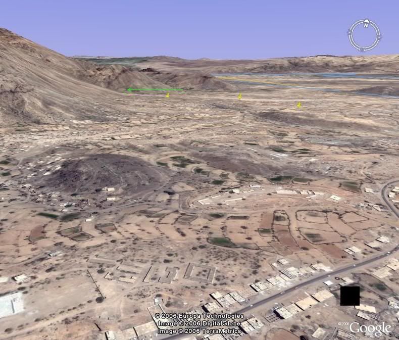
Using your location of the camps, below are two views across that area. Note the compass in the top right indicating alignment. Does that help?
Also the white line that I drew on the previous aerial shot was 4500 feet long - that was your suggested runway length in an earlier post so it would not fit very well in the red box.
And if you know the distance of the airfield from the camp, does that 0.8 mile line help to locate it?
Ian
Edit: pictures removed
Last edited by ianhind on 11 Nov 2006, 17:33, edited 1 time in total.
-
petermcleland

- Red Arrows

- Posts: 5201
- Joined: 25 Jul 2004, 10:28
- Location: Dartmouth, Devon
- Contact:
Surely that is the airfield in the centre of the first picture and a bit right of centre in the second picture?
Regards,

http://www.petermcleland.com/
Updated 28/8/2007
My Channel
http://www.youtube.com/user/petermcleland?feature=mhee
http://www.petermcleland.com/
Updated 28/8/2007
My Channel
http://www.youtube.com/user/petermcleland?feature=mhee
Hi Ian, thanks for the latest pics, the camps 2 looks promising if you can get one looking along the length towards the hill maybe we could see the end of the runway with the turnaround if it is still there as per the green arrow.
Peter the straight bit in camps 1 is to close and the wrong direction, from memory ??!!! getting worn out now, the distance to the strip was around 2 miles maybe a little less.Also there is no cliff face close to the end of that where camps 2 looks as if the left end could extend into the base of the hill.
This pic I nicked of my old army mate Wobbly Willoughby's site its the best I have found of the camp and may give a clue with the three hills close in formation, yellow box FRA camp,blue box was us,green was Little Temple with a wombat anti tank gun + crew perched up there so rumor had it.
The red line is roughly the track the Hunters flew, they looked and sounded manificent at that level, the small dark green arrow is roughly the direction of the strip.
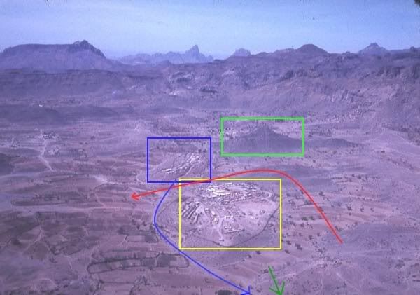
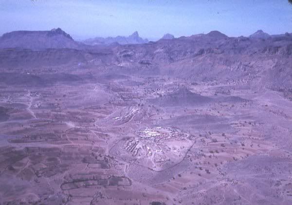
The last pic is doodle free
Peter the straight bit in camps 1 is to close and the wrong direction, from memory ??!!! getting worn out now, the distance to the strip was around 2 miles maybe a little less.Also there is no cliff face close to the end of that where camps 2 looks as if the left end could extend into the base of the hill.
This pic I nicked of my old army mate Wobbly Willoughby's site its the best I have found of the camp and may give a clue with the three hills close in formation, yellow box FRA camp,blue box was us,green was Little Temple with a wombat anti tank gun + crew perched up there so rumor had it.
The red line is roughly the track the Hunters flew, they looked and sounded manificent at that level, the small dark green arrow is roughly the direction of the strip.
The last pic is doodle free
Rich
-
petermcleland
- Red Arrows
- Posts: 5201
- Joined: 25 Jul 2004, 10:28
- Location: Dartmouth, Devon
- Contact:
OK,
Thanks Ian,
I flew "Recce One" in a Venom FB4 from Khormaksar on March 4th 1959...Recce One was Dhala and Alkara...Sadly, I can remember nothing of Dhala, probably because the sight of Alkara was so awe inspiring. However, I find all these pictures extremely interesting and I'm very surprised to see so many buildings.
We flew these recces in pairs...An experienced 8 squadron pilot flew the lead and I, as a new to the area pilot, flew number two.
The next day I flew "Recce Two"...Lauder, but I'm adraid that one has faded into the mists of time
Regards,
http://www.petermcleland.com/
Updated 28/8/2007
My Channel
http://www.youtube.com/user/petermcleland?feature=mhee
http://www.petermcleland.com/
Updated 28/8/2007
My Channel
http://www.youtube.com/user/petermcleland?feature=mhee
Rich
A further sequence of shots, mostly as URLs rather than displayed images to avoid boring the readers!
1 line shows runway length (0.8 mile) and approx heading (053deg)

2 view looking into the area you marked with green arrow
http://www.btinternet.com/~calypsomedia ... d/seq2.jpg
3 parallel to runway heading near ground level
http://www.btinternet.com/~calypsomedia ... d/seq3.jpg
4 looking across again at area marked with green arrow
http://www.btinternet.com/~calypsomedia ... d/seq4.jpg
5 ditto, from different angle
http://www.btinternet.com/~calypsomedia ... d/seq5.jpg
6 view from camp
http://www.btinternet.com/~calypsomedia ... d/seq6.jpg
7 move "runway" nearer cliff
http://www.btinternet.com/~calypsomedia ... d/seq7.jpg
8 view from end of moved runway
http://www.btinternet.com/~calypsomedia ... d/seq8.jpg
9 aerial view of moved runway with your current AFCAD location, a location I found for "dhala airport" and another possible location mentioned on the web.
http://www.btinternet.com/~calypsomedia ... d/seq9.jpg
10 same scenario but from ground level
http://www.btinternet.com/~calypsomedia ... /seq10.jpg
Hence in the correct area!
I will comment on Al Abilayne in another post.
Ian
A further sequence of shots, mostly as URLs rather than displayed images to avoid boring the readers!
1 line shows runway length (0.8 mile) and approx heading (053deg)
2 view looking into the area you marked with green arrow
http://www.btinternet.com/~calypsomedia ... d/seq2.jpg
3 parallel to runway heading near ground level
http://www.btinternet.com/~calypsomedia ... d/seq3.jpg
4 looking across again at area marked with green arrow
http://www.btinternet.com/~calypsomedia ... d/seq4.jpg
5 ditto, from different angle
http://www.btinternet.com/~calypsomedia ... d/seq5.jpg
6 view from camp
http://www.btinternet.com/~calypsomedia ... d/seq6.jpg
7 move "runway" nearer cliff
http://www.btinternet.com/~calypsomedia ... d/seq7.jpg
8 view from end of moved runway
http://www.btinternet.com/~calypsomedia ... d/seq8.jpg
9 aerial view of moved runway with your current AFCAD location, a location I found for "dhala airport" and another possible location mentioned on the web.
http://www.btinternet.com/~calypsomedia ... d/seq9.jpg
10 same scenario but from ground level
http://www.btinternet.com/~calypsomedia ... /seq10.jpg
Hence in the correct area!
I will comment on Al Abilayne in another post.
Ian