NEXTMap® ProMesh United Kingdom (Includes Scotland)
Posted: 29 Jul 2008, 21:05
NEXTMap® ProMesh United Kingdom (Includes Scotland)
Hi Folks
FS Dreamscapes have released NEXTMap® ProMesh United Kingdom.
A 4.75m terrain mesh product for Microsoft® Flight Simulator X.
Covering England, Wales, & Scotland.
Based on InterMap's NEXTMap® Digital Terrain Model (DTM) data.
(Same provider to Horizon).
The DTM provides an accurate, high density and complete height dataset covering Great Britain.
More commonly known as a "Bald Earth" model, the data removes all trees, buildings and other man-made structures to leave the underlying terrain height information.
The resulting mesh has a -
* 5m horizontal post spacing.
* +-1m RMSE vertical resolution.
Pros -
Includes Scotland
Plus mesh for various outliers -
- Scilly Isles
- Orkneys
- Shetland
- Foula
- St Kilda ***
- Sula Sgeir ***
- North Rona ***
- Sule & Stack Skerry ***
- Coquet Island ***
- Flatholm ***
- Steepholm ***
Does not cover -
- Northern Ireland
- Isle of Man
- Channel Islands
- Lundy Island
- Stack Skerry
- Boreray, Stac An Armin, Stac Lee.
Cons -
Items suffixed *** will require 3rd party addon scenery to display.
Due to processing method,
is very slightly vertically less detailed than Horizon's GenX v2 England & Wales mesh.
Please note -
Some of the claims made on the website are factually incorrect.
The product title is technically incorrect -
The mesh only covers Great Britain.
Northern Ireland is not included.
Website screenshot does not correctly reflect coverage, (see above).
Mesh vertical resolution is to nearest 1/4 metre, (not 1/25th as claimed).
Mesh is 256 times more detailed than FSX default, (not 128 times as claimed).
Recommendations -
Scotland -
To get the most out of the Scotland area mesh,
use alongside either UTX Europe, or Scotflight for FSX.
England & Wales -
Place below Horizon's Generation X v2.
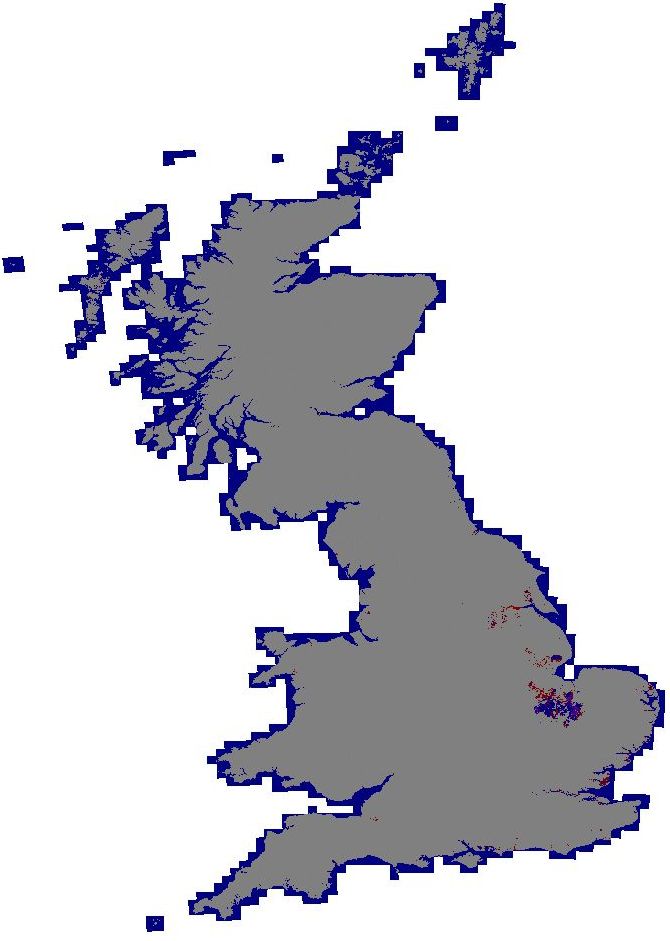
True Coverage -
Downloads -
Currently on offer at £22.55
http://www.fsdreamscapes.com/store/prod ... ucts_id=32
EDIT -
Forgot to add,
after costs, remaining profits are to go to charity.
HTH
ATB
Paul
Hi Folks
FS Dreamscapes have released NEXTMap® ProMesh United Kingdom.
A 4.75m terrain mesh product for Microsoft® Flight Simulator X.
Covering England, Wales, & Scotland.
Based on InterMap's NEXTMap® Digital Terrain Model (DTM) data.
(Same provider to Horizon).
The DTM provides an accurate, high density and complete height dataset covering Great Britain.
More commonly known as a "Bald Earth" model, the data removes all trees, buildings and other man-made structures to leave the underlying terrain height information.
The resulting mesh has a -
* 5m horizontal post spacing.
* +-1m RMSE vertical resolution.
Pros -
Includes Scotland
Plus mesh for various outliers -
- Scilly Isles
- Orkneys
- Shetland
- Foula
- St Kilda ***
- Sula Sgeir ***
- North Rona ***
- Sule & Stack Skerry ***
- Coquet Island ***
- Flatholm ***
- Steepholm ***
Does not cover -
- Northern Ireland
- Isle of Man
- Channel Islands
- Lundy Island
- Stack Skerry
- Boreray, Stac An Armin, Stac Lee.
Cons -
Items suffixed *** will require 3rd party addon scenery to display.
Due to processing method,
is very slightly vertically less detailed than Horizon's GenX v2 England & Wales mesh.
Please note -
Some of the claims made on the website are factually incorrect.
The product title is technically incorrect -
The mesh only covers Great Britain.
Northern Ireland is not included.
Website screenshot does not correctly reflect coverage, (see above).
Mesh vertical resolution is to nearest 1/4 metre, (not 1/25th as claimed).
Mesh is 256 times more detailed than FSX default, (not 128 times as claimed).
Recommendations -
Scotland -
To get the most out of the Scotland area mesh,
use alongside either UTX Europe, or Scotflight for FSX.
England & Wales -
Place below Horizon's Generation X v2.
True Coverage -
Downloads -
Currently on offer at £22.55
http://www.fsdreamscapes.com/store/prod ... ucts_id=32
EDIT -
Forgot to add,
after costs, remaining profits are to go to charity.
HTH
ATB
Paul