Developed areas ( Europe and the USA) were not really that different from today with a wide selection of VOR and NDBs . Off the beaten track - Asia, Africa and South America , VORs were very much less common and the bulk of aids were NDBs - in Russia this still applies. Over water and sparsely settled areas such as Saharan Africa the norm was astro navigation with a bubble sextant , and of course the same applies in the polar regions where compasses are wholly unreliable , and virtually all long distance aircraft up to the introduction of INS with the 747 in 1970 were equipped with an astrodome or periscope to enable sights to be taken
Very interesting, thanks for the info.
Garry Russell wrote:In the fifties at least, they often used to time some of the flights so certain sections of the Sahara would be flown at night to use astro navigation.
Gary,
I actually have been doing that for my long range flights over water. I time the arrival to about 30 minutes into full daylight so that I can navigate most of the time with the stars. For the Antartica flights, I have a solar compass gauge that helps me with directions using grid navigation, but can only work on full daylight so hence the daylight arrival necessity. By that time I should be very close to a radio nav aid or able to use pilotage anyway; now if bad weather and no radio aids, then that is trouble...

.
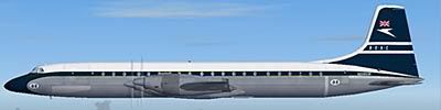
The reason why I was asking this question was because I want to fly one of the segments as shown in the video. The Enteebe to Livingston leg looks interesting, but wanted to fly it the way it used to be flown in those days (with the Comet of course). I planned for a direct route, using celestial nav as the main check and what ever NDB's were available in those days as I assume they might have been. Some period nav charts woudl be really nice to have, I wonder if anybody might have one of those around to make a scan

.Thanks for your help,
regards,
Macs


